The software for the MOS mask design requires an image which is distortion-free with an accurately-measured pixel scale (we refer it as "preimage" below). A mosaicked image by MOIRCS (reduced by the pipeline software MCSRED) is usually used(*1). But any "recent (<5yr)" data with accurate pixel scale can also be used after converting it to the MOIRCS pixel scale (see below). If you don't have such data, we can take the short-exposure data of your MOS fields on request.
The observation for preimages is usually executed 2 to 4 months prior to your actual MOS observation, so that we can take it during the morning time of the other MOS observers(*2). The number of the preimaging fields should be equal (or less than) the number of the MOS mask approved by TAC: namely we do not accept any back-up preimaging fields. This is because we usually have to take your data by depriving the time of other programs that are unrelated to you for most cases. So, as a policy, the preimaging fields should be minimal. The other reason is that currently we cannot accept the back-up MOS masks due to the limited number of the available MOS slots.
(*1) !!Important!! The pixel scale of the reduced image by the MCSRED2 for new detector (since 2016) has changed to 0.1160/pix. On the other hand, the mask design program (wmdp_moircs.sav) still assume it is 0.1170"/pix. You have to change the pixel scale if the data is reduced by MCSRED2. This issue will be fixed in the near future. Note that the SA will usually provide the reduced preimage after converting it to 0.1170"/pix.
(*2) As an observatory policy, we will ask you to complete your observation 1 hour before sunrise for taking preimage. The actual plan for the preimage should vary time to time, so please ask about the actual preimaging observation plan during your run to the SA. Though we will try it not tot happen, we may inevitably have to ask taking preimages during your observation (not in the morning time) if taking the data during the morning time is impossible. We really appreciate your cooperation and understanding.
As we should minimize the loss of the other open-use observers' time for your preimaging data acquisition, we want to keep the exposure for preimaging to minimum. By default, the preimaging data is taken under 20 second exposure, with 5- to 7-times dither (default is 20")(*3). It will not go so deep as to be able to detect objects as faint as Ks~20 mag. What we suppose you to do on the preimage is to register your deep images on that preimaging data and choose your targets from it, not from the preimage itself(*4). Please note that the world coordinate system (wcs) on the MOIRCS fits header is poor unless it is corrected. If you want to use it, you have to put the correct wcs on the image header by yourself by your own responsibility.
(*3) If you need the exposure deeper than the default for the preimage, please explicitly request it in the proposal (in Section 15: Technical Justification part, with date and the required total exposure time) so that the time for your preimages can be scheduled at the beginning of the semester. However, as we are doing the operation in classical observation way, there is always the risk of a bad weather so the data acquisition is not guaranteed.
(*4) This can be done by the IRAF tasks geomap and geotran. Be very careful to the object coordinates used for image matching. If the image you use is older than 10 years, the move of the stars by proper motion might be significant. If you are not familiar to the image matching process, you can contact the SA for help.
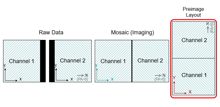
After we take your preimaging data, we will do a quick reduction and send them to you as soon as possible. The data reduction of the preimages is executed as follows. Firstly the raw data is flatfielded (by self-flats), sky-subtracted, and distortion corrected. After pasting each channel 1 and 2 data at the "shadow" region by the beam-splitting roof mirror to make a set of mosaic images, they are registered and median-combined. Note that the relative sensitivity difference between ch1 and ch2 may not take into account for preimage (though we may try). Then the resulting combined image is rotated to counterclockwise by 90 degrees so that the channel-2 image goes over the channel-1 image (which makes the image layout north is up and east is to the left under PA=0).
As is noted above, the pixel scale of the mosaic image by the MCSRED2 pipeline is 0.1160"/pix, not the old value of 0.1170"/pix. When the SA sends the preimage data to observers, we will convert it to 0.1170"/pixl. But it is always better to do cross-check.
Please note that the mosaicking rule we use in the mosaicking software is a "canonical" one which is based on the set of images we took near the zenith. The actual mosaicking rule for your preimaging data may differ from this a bit due to the gravitational flexure. Therefore we do not recommend to use the data taken at elevation lower than 45 degrees. We will try to take your preimage at the elevation higher than 60 degrees to avoid the effect of the flexure. If you try to do MOS observation to the targets that does not go up higher than 50 degrees, please be aware that the alignment accuracy may be worse than usual (though the previous experiences all worked fine).
You should aware that the preimage reduction is aimed for the mask design, not for science. If you want to use the preimage data for science, we recommend to do the data reduction more carefully from the raw data. As we usually do not provide the raw data of your preimage, you can ask for it to the SA if you want to receive the raw data.
- Our Hawaii-2RG detector has several small bad-pixel clusters. You can take them into account for the mask design. Note that the detector for channel-1 has a better characteristics than the channel-2 detector. You may want to put higher-priority target on channel-1. See the Detector Information page for detail.
- Currently the area available for putting slitlets is limited to within the 6'-diameter circular region in the FOV, not the whole 4' by 7' MOIRCS fov, as shown in the Figure 9 of the MOS page. It may be changed in the future.
- You do not need to measure the coordinates of the preimage with too much accuracy, because the pointing accuracy is sometimes limited to several arcseconds. The pointing position is the center of the 4' x 7' FOV after mosaicking (1024,1818 for the MCSRED2-reduced preimage).
- The position angle (PA) is defined as counterclockwise of the MOIRCS f.o.v. on the sky after mosaic, with PA=0 when the channel-2 side is to the North. See the MOIRCS FOV page for explanation.
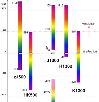
- As is shown in the Figure 9 of the MOS page, the spectra of each channel is separately falls on each detector. Even though the spectra in one channel apparently goes on the other channel in the mask design software display, the actual spectra will be terminated at the end of the detector.
- Targets close to the preimage center (assuming you do not shift the center fov during the design) cannot put the slit: i.e. avoid putting targets several arcsec around the boundary of chip 1 and 2 mosaic. Also, we recommend to avoid putting targets ~10 arcsec close to the edge of the preimaging fov.
- The spectra from a slitlet extends differently with the different grism settings. Be careful not to drop the wavelengths of your interest off the detector. Below is a rough position of the spectra for each setting. In the preimage coordinate, longer-wavelength direction is -Y for channel 1 and +Y for channel 2.
- Typical slit length is around 5 to 10 arcseconds. Shorter slit length will gain the multiplicity, though it may be with more risk of a poor sky subtraction due to a lesser sky sampling area.
- Bright stars are used for the alignment of the MOS mask and the target. These "alignment stars" should be more than two on each channel, i.e. at least ›5 stars are recommended. Please select stars with 11 mag ‹ Ks ‹ 17 mag. Choosing stars with similar magnitude for alignment would be better, though we can ignore the saturated or too faint stars during the alignment. If you have a MOIRCS preimage, you can just choose the star unsaturated and good SN for alignment stars from it. For more information, please refer the section 3.3 of the MOIRCS MDP manual.
- You can shift or rotate the preimage provided by the MOIRCS SA if necessary. However, the mistake during the post-processing of the preimage is the main cause of the errors during the MOS alignment. Please make sure to do it very carefully.
- If you want to run the mask design software before preimaging observation using your data other than MOIRCS, you have to convert the pixel scale of your data to 0.1170 arcsec/pixel. You can download the mask design software from the wmdp_moircs website. Cuting the image size to 2048 x 3636 to mimic the preimage might also be more convenient.
We need to use the Autoguider during the spectroscopic observation. We strongly recommend to check the availability of the Autoguider stars before you finalize the preimaging coordinates. You can find the description of the AG selecting area in the "Spectroscopy Information" webpage below.
-
Go to MOIRCS Spectroscopy Mode: Information -- AutoGuider Issue.
If your target fields are in dark clouds or in high latitude fields with very few bright stars, finding the suitable star for AutoGuider could be difficult. To prevent the failure of the observation, we strongly recommend to check the AG star before finalizing the preimaging FOV.
The use of images taken other than MOIRCS for preimage is also possible, under some condition.
Firstly the image have to be distortion-free (tangential projection). Secondly, its pixel scale have to be converted to 0.1170"/pix very accurately (the accuracy of 0.05% or better is required)(*5)(*6). Thirdly, it have to be relatively new (<5 years are recommended) so that the proper motion of the alignment stars is not the problem(*7). If these condition is satisfied, you can use the data under your own risk. We have the experience of the successful alignment for FOCAS, Suprime-Cam, HSC, Pan-Starr, Hawk-I, WFCAM, HST ACS & WFC3 etc.
(*5) The accrate pixel scale of MOIRCS preimage data reduced by MCSRED1/2 package actually has a slight uncertainty. We still recommend to take at least a part of your fields even if you are planning to use your own data as a cross check. The use of any images that are well distortion-corrected should work in priciple, if the magnification factor of the pixel scale is measured well by the MOIRCS data.
(*6) We should note that the mosaicking rule we apply for MOIRCS preimage data reduction is a canonical value. The mosaic data might suffer from the affection of the flexure, especially if it is taken at lower elevation. In that sense, the other imaging data taken by single CCD or single IR array has the advantage, as there is no uncertainty of the mosaic. Indeed we sometimes see even better alignment result for the data based on FOCAS or Suprime-Cam.
(*7) Sometimes the archived data taken by Suprime-Cam or HST ACS are already fairly old (>10 years). We have sometimes seen significant increase of the scatter in the residual vector during the alignment, due to the additional errors by the proper motion of the stars. If you have to use the old data for preimage, a strategy is to increase the number of the alignment stars, so that we can reject the stars with large proper motion manually on-site.
Please send the coordinate information of your preimaging fields using the following format to the SA by email. The SA will send the confirmation email within a couple of days. The submission should be BEFORE the date when your targets become available (EL › 45 degrees) in the morning sky (1hr before sunrise). The delay of the submission may result in the failure of taking preimage. The early preparation and submission is always welcomed.
The format of the preimage is as follows.
TANAKA1=OBJECT=TANAKA_TARGET1 RA=123456.78 DEC=+123456.7 EQUINOX=2000.0 PA=0.0- Change the name (TANAKA_TARGET1) and its abbreviation (TANAKA1) as you like.
- The format of RA and DEC is in hhmmss.ss and ddmmss.s, respectively. For above case, it is RA=12h34m56.78s, DEC=12d34m56.7s
Put the RA, DEC, and PA very carefully because we do not check the fields individually. Sending correct coordinate is the responsivility of users. Usually we cannot acquire your preimages again even if you found it is worng due to a typo. You do not need to submit the finding charts for preimages because we usually have no time to check it on site. If you want the preimage other than Ks bands, you can explicitly request it when you submit the coordinates.
Though we will try to take your preimage as much as possible, we cannot guarantee the acuqisition because we are running the observation in classical mode and so there is always a risk of losing the time by bad weather. We are asking all the MOIRCS observers (especially MOS observers) to share a bit of your time for others for preimaging observation. We really appreciate your understanding and cooperation.
If you have any question, please send emails to Ichi Tanaka.